Estreito da Calheta
Appearance
Estreito da Calheta | |
|---|---|
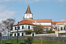
 The centre of the parish of Estreito da Calheta | |
| Coordinates: 32°45′28″N 17°10′34″W / 32.75778°N 17.17611°W | |
| Country | |
| Auton. region | Madeira |
| Island | Madeira |
| Municipality | Calheta |
| Area | |
| • Total | 14.32 km2 (5.53 sq mi) |
| Population (2011) | |
| • Total | 1,607 |
| • Density | 110/km2 (290/sq mi) |
| Time zone | UTC+00:00 (WET) |
| • Summer (DST) | UTC+01:00 (WEST) |
| Postal code | 9370-111 |
| Area code | 291 |
Estreito da Calheta (Portuguese for strait of Calheta) is a civil parish in the municipality of Calheta in the Portuguese island of Madeira. The population in 2011 was 1,607,[1] in an area of 14.32 km2.[2]
References
[edit]- ^ Instituto Nacional de Estatística
- ^ Eurostat Archived October 7, 2012, at the Wayback Machine


